
Project Overview
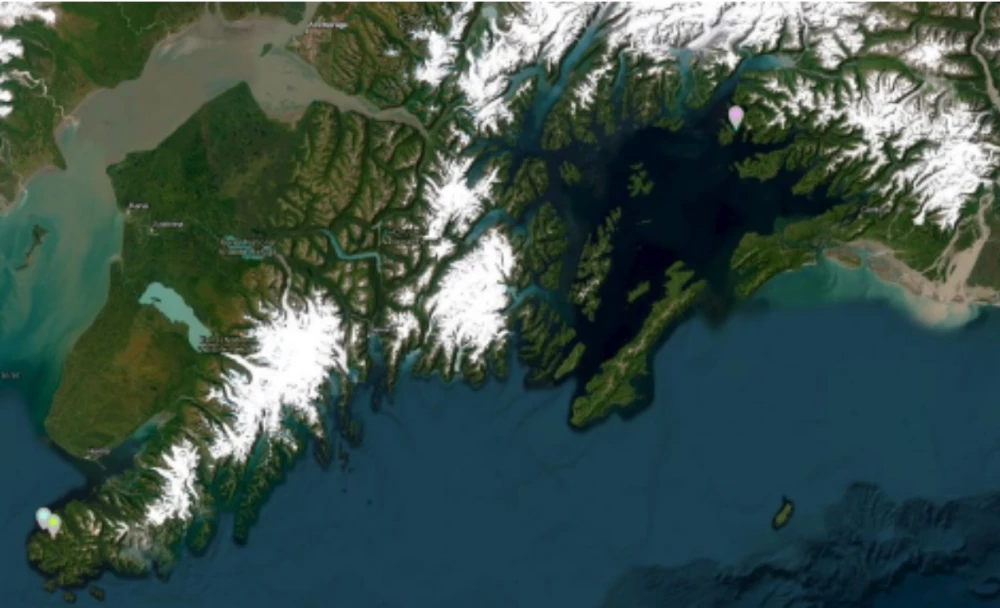
The project aims to evaluate selected subsistence beaches near seven native communities in south central Alaska. The Chugach Regional Resources Commission through funding by the Exxon Valdez Oil Spill Project 97-131 conducted extensive beach surveys identifying shellfish populations and biological and water quality factors for beaches identified by local residents as historical sources of shellfish namely cockles, littleneck and butter clams. Those beaches were then seeded and growth and mortality studies continued for several years. This project aims to re -survey these beaches and document changes, if any, and provide a baseline to determine if the beaches are still suitable for enhancement. Of the original beaches surveyed only three areas near Port Graham, Tatitlek and Chenega were successful with efforts in the 1990’s. Updated technology, including enhanced seeding and predator control efforts warrants another look at these beaches and their suitability for robust enhancement. Researchers will use identical techniques employed in 1990 to ensure equal assessment but will also include newer technologies and strategies employed by PSI which conducts similar work throughout the PNW. Once evaluated, beaches will be selected for future outplant and enhancement work. Understanding and analyzing the characteristics of intertidal areas is requisite for building a successful enhancement project.
Interim Report
The beach surveys took place on August 28th, August 31st, and September 1st at three beaches in the Chugach Region. These sites were selected due to their historical significance as shellfish harvest locations and were previously surveyed in the 1990s with funding from the Exxon Valdez Oil Spill Project 97-131. The first beach that was surveyed is located at a site adjacent to the Village of Tatitlek, while the other two beaches (Passage Island and Beyond Dick’s) are located near both the Native Village of Nanwalek and the Native Village of Port Graham. Researchers employed systematic random quadrat sampling to quantify the number of bivalve species and their population at each site. Sediment samples were taken to assess habitat suitability, and GPS coordinates were recorded at each quadrant and sediment sample to enable precise georeferencing and mapping. These data will enable researchers to create population density and habitat maps using GIS software. Currently, Alutiiq Pride Marine Institute and the Pacific Shellfish Institute are finalizing the density and habitat suitability mapping for all three sites.
Beach Surveys
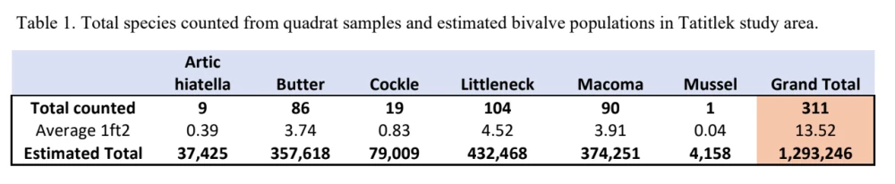
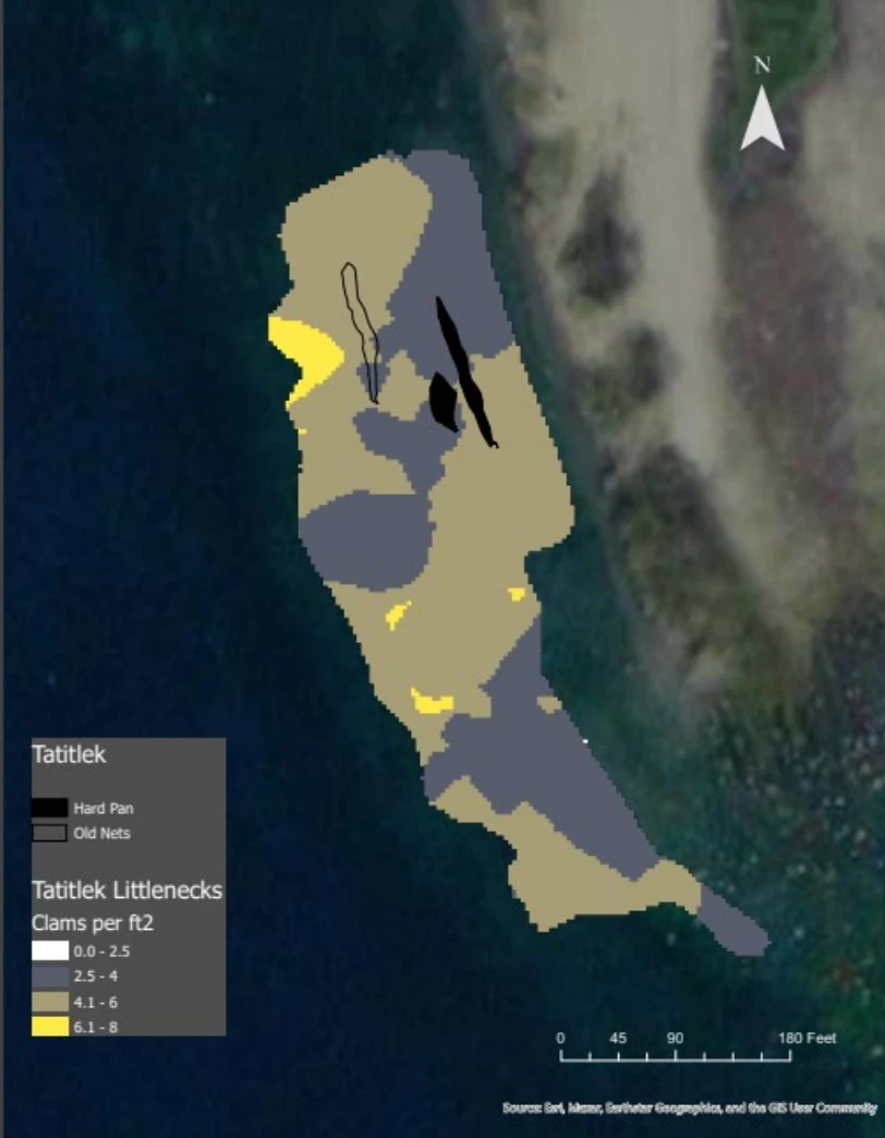
Tatitlek, August 28th, 2023: Jeff Hetrick, Andy Suhrbier, and Annette Jarosz traveled to Tatitlek to survey the local beach for shellfish densities and habitat suitability. At the designated beach, an area of 95,600 ft2 was defined by placing boarder flags. This area encompassed a -2 and +2 tide. Once the area was defined, researchers used a systematic random design to create the grid for quadrat and sediment sampling. A total of 23 quadrats were placed and sampled. Due to poor weather conditions, the drone was not able to capture pictures of the study area.
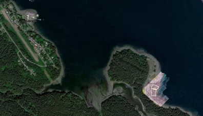
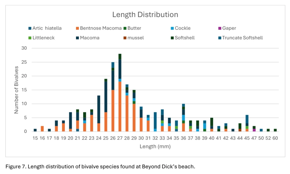
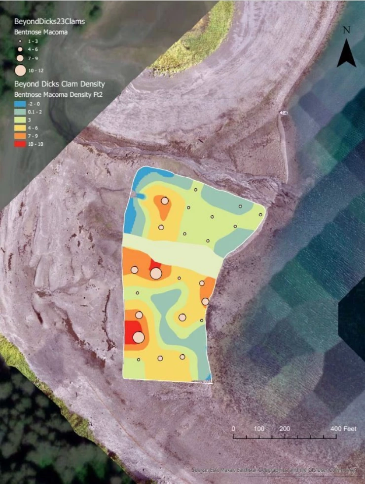
Beyond Dick’s Beach, August 31st, 2023: Jeff Hetrick, Andy Suhrbier, Briana Murphy, Annette Jarosz, and two tribal members traveled from Port Graham to Beyond Dick’s beach. An area of 308,000 ft2 was defined using flags. This area encompassed a -2 and +2 tide. Once the area was defined, researchers used a systematic random design to create the grid for quadrat and sediment sampling. A total of 32 quadrats were placed and sampled. Due to poor weather conditions, the drone was not able to capture pictures of the sample area on the 31st but researchers were able to travel back to the beach on September 1st and use the drone to photograph the survey site.
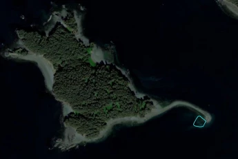
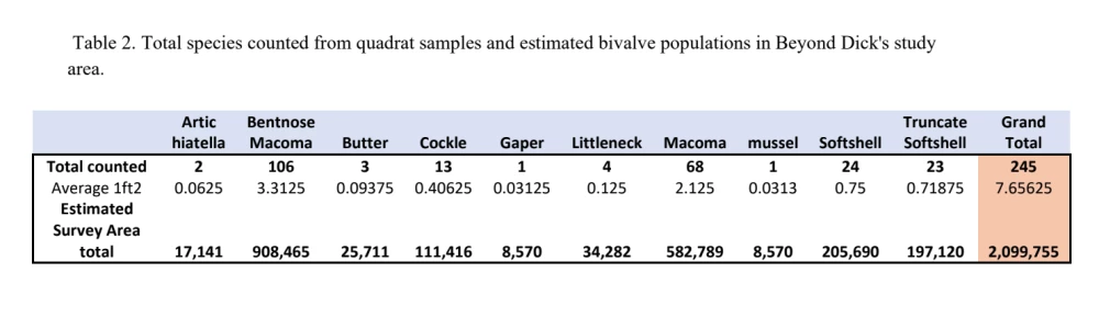
Passage Island, September 1st, 2023: Jeff Hetrick, Andy Suhrbier, Annette Jarosz, and a tribal member traveled from Port Graham to a beach on Passage Island. An area of 64,000 ft2 was defined using flags. This area encompassed a -2 and +2 tide. Once the area was defined, researchers used a systematic random design to create the grid for quadrat and sediment sampling. A total of 25 quadrats were placed and sampled. The weather conditions allowed for the use of the drone to capture pictures of the study site.
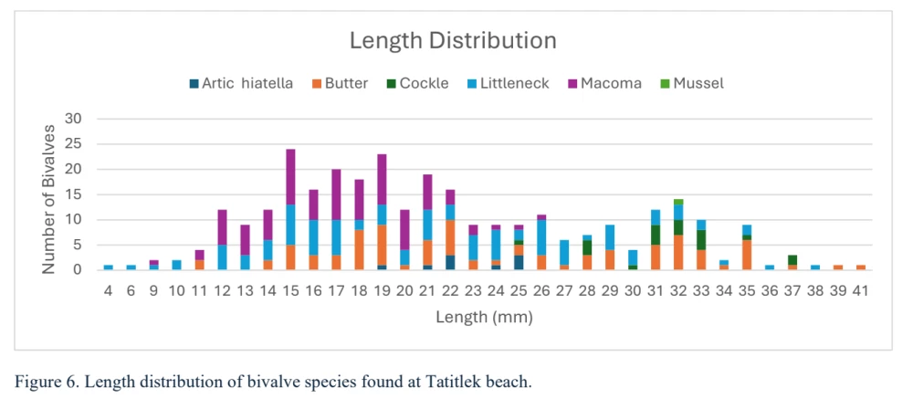
Preliminary Results from Quadrat Samples:
See photo slides
Preliminary Results from GIS Mapping
With the support of Andy Suhrbier, APMI staff are continuing to use the results from the beach surveys to create population density maps for each bivalve species for all three study areas. Figures 9 and 10 are examples of what the density maps look like. These maps can be provided to tribes to be used as a tool for conservation and aid in shellfish harvesting.
See photo slides